Bechenka River Canyon
Experience the ancient soul of the Silk Road.
Detailed History & Context
The Layers Bechenka Keeps
The river cuts through limestone slowly enough that you can see the centuries in the walls. Geologist Serik Abenov, who has been studying the canyon formation for over a decade, says the Bechenka is of the few places in the Turkistan region where geology and human history occupy the same visible stratigraphy — different kinds of record, written in different languages, both telling the same story of time moving through a landscape.
The canyon sits in the orbit of Turkistan, the spiritual and political center of the Kazakh steppe, which means its human story begins not with any colonial administration but with the long Kazakh occupation of the Syr Darya basin. The Saka — Iron Age horse cultures who ranged across the steppe from the Caspian to the Altai from the 5th century BCE — left burial mounds in the elevated ground above many of the region's river systems. The Bechenka valley shows signs of this early human presence, its accessible walls and reliable water making it a natural shelter and gathering point for people moving across the southern steppe.
The Silk Road transformed the Syr Darya basin into of Central Asia's most consequential corridors. Caravans moving between Samarkand and the interior of the Kazakh steppe passed through Turkistan — then called Yasi — and the surrounding landscape. The trade routes followed river systems when possible, and small canyons like Bechenka served as waypoints: fresh water, shelter from steppe wind, and the particular privacy of a rock formation that could hide a camp from the sight of the open plain.
By the time the Kazakh Khanate was founded in 1465 by Janibek and Kerei Khans along the Chu and Talas rivers, the Turkistan region had become central to Kazakh political and spiritual identity. Khoja Ahmed Yasawi — the 12th-century Sufi poet and mystic whose mausoleum still anchors the city of Turkistan — had already made the area sacred in a way that outlasted multiple political transitions. The Kazakh khans understood this and maintained Turkistan as a symbolic seat of power across the centuries of the Khanate's existence.
The Dzungar invasions of the early 18th century shattered much of the settled life of the southern steppe. Kazakh communities were displaced, trade routes disrupted, and the population of the Syr Darya basin — including the areas around Bechenka — suffered catastrophic losses. The Russian annexation that followed, beginning in 1731 with the submission of the Elder Zhuz under pressure and continuing through the full pacification of Kazakhstan by the 1840s, brought a different kind of disruption: the deliberate erosion of the Kazakh administrative and land systems, and the conversion of nomadic range into territory administered from St. Petersburg.
The canyon's natural form kept it somewhat separate from the administrative transformations of the Russian colonial period. It was not farmland; it was not a trade center. It persisted as a local feature — known to the Kazakh communities of the surrounding region as a place for gathering, hunting, and the kind of quiet seasonal use that left few official records. Soviet cartography mapped it, Soviet archaeologists eventually surveyed it, but it remained, functionally, a place that belonged more to the land than to any particular political project.
Independence in 1991 brought new interest in the cultural geography of the Syr Darya basin. The rehabilitation of Kazakh history — the naming, reclaiming, and recontextualizing of places that had been processed through Soviet administrative language — included a renewed attention to sites like Bechenka that had always been present in local knowledge but rarely featured in official heritage frameworks. The canyon sits within reach of Turkistan, now a city undergoing significant investment as a center of Kazakh cultural and religious identity. It belongs to that constellation of landscapes — modest in tourist infrastructure, significant in layered meaning — that reward visitors who come looking for depth rather than spectacle.
Digital Logistics & Access
Getting to Bechenka River Canyon
Bechenka River Canyon lies in the Turkistan region of southern Kazakhstan, making it a natural addition to any trip centered on the Syr Darya basin — Turkistan city, the Yasawi Mausoleum, the ancient settlement of Otrar, and the surrounding steppe landscapes all fall within reasonable driving distance.
From Turkistan
The canyon is the closest excursion from Turkistan city, reachable in under an hour by car. The road heading south from the city toward the Syr Darya connects to the canyon access route; local drivers and guesthouse owners know the way reliably. Agree on a fare before departure and confirm the driver will wait or return at a set time — there is no taxi infrastructure at the canyon itself.
From Shymkent
Shymkent is the regional hub and the likely arrival point for most international visitors — the city has a commercial airport with connections to Almaty, Astana, and some Central Asian destinations. From Shymkent, Turkistan is roughly 160 kilometers north, around two hours by road. Shared taxis (marshrutki) run between the two cities throughout the day and are the most affordable option. From Turkistan, arrange transport to the canyon.
By Train
The high-speed rail line connecting Almaty to Shymkent and continuing to Turkistan has made the southern route significantly more accessible. Turkistan has its own station, and the train from Almaty takes around three to four hours. From the Turkistan station, hire a local taxi for the canyon excursion.
At the Site
The canyon has basic visitor infrastructure — a car park, marked trail entry points, and information signage. It does not have a staffed visitor center on the scale of a national park. Entry fees are minimal and collected at the access point; confirm current pricing locally before you go, as rates update periodically.
Mobile coverage is inconsistent inside the canyon. Download any maps you need before leaving Turkistan. Bring your own water — there are no food or drink vendors at the canyon itself. The nearest facilities are back in Turkistan city.
Practical Notes
The canyon is at its most pleasant from April through June and in September and October. July and August bring genuine heat to the southern steppe — temperatures in the canyon can exceed 40°C in the afternoon, and the limestone walls trap the warmth after the sun passes overhead. Early morning visits in summer are markedly more comfortable. Sturdy shoes are worth wearing; the canyon floor has loose rock in sections, and some of the ridge paths above the walls require sure footing.
5+ Specific Activities
What to Do at Bechenka River Canyon
Photographer Nurgul Seitkali drove from Shymkent specifically for the light. She'd heard about the canyon walls at golden hour from a friend — the way the limestone catches the late afternoon sun and holds it, the stone going from pale yellow to a deep amber that she described as "like the steppe poured itself into rock." She got the shot. She also spent two hours sitting on a ledge above the canyon floor watching a kestrel hunt the thermals, which hadn't been part of the plan at all.
Walk the Canyon Floor
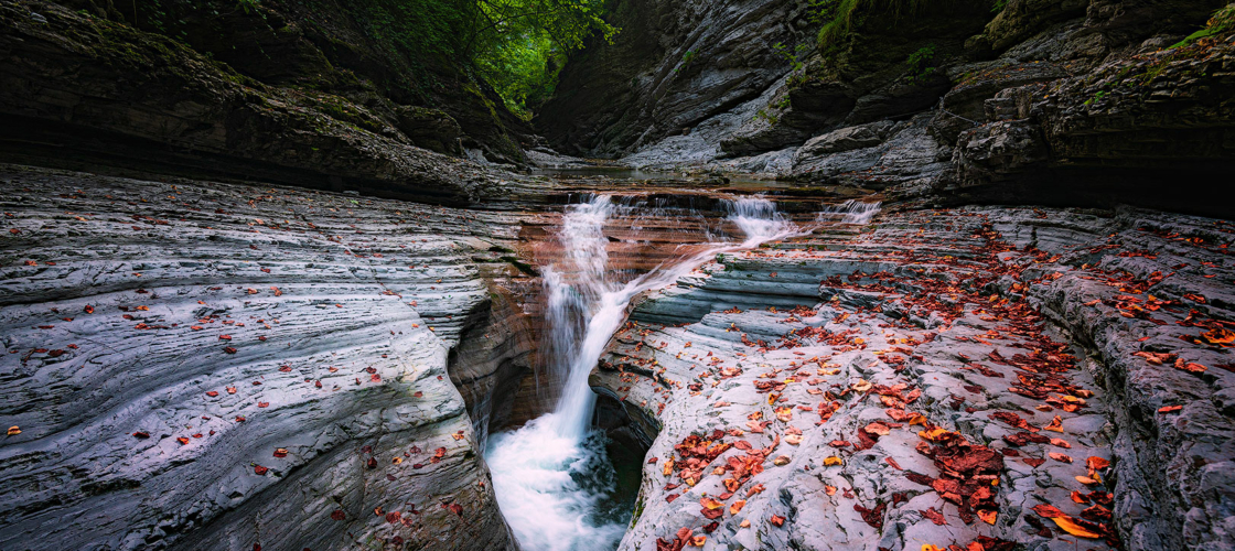
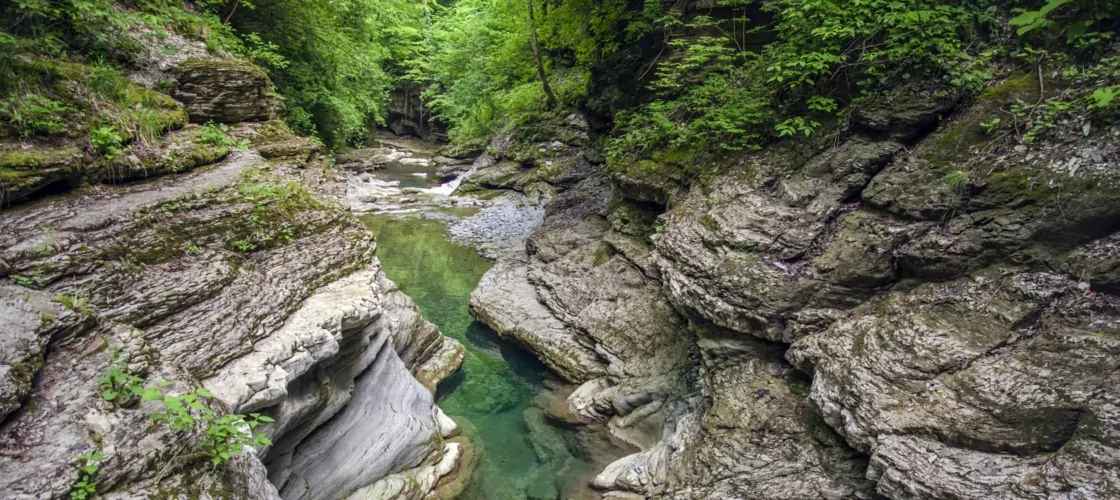
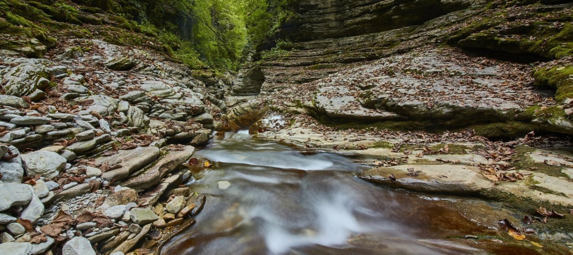
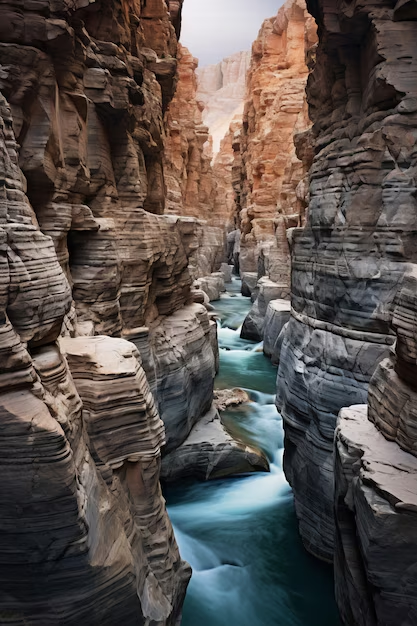
The primary trail follows the canyon bottom, navigating between the limestone walls for roughly three to four kilometers before the terrain opens back the steppe plateau. The walk takes between and two hours at an easy pace, depending on how often you stop. The geology is varied and legible — layers of deposited sediment compressed into visible bands across the canyon walls, with sections of exposed fossil material in places. This is not a specialist trail; it requires ordinary fitness and sensible footwear.
Climb to the Ridge
A second trail branches upward from the canyon floor about halfway through, climbing a series of switchbacks to the top of the eastern wall. The view from the ridge looks south toward the Syr Darya basin and north across the steppe plateau — a wide, flat horizon that makes clear how the canyon hides itself until you're standing on its edge. Allow an extra hour for this detour. The climb is moderate; loose rock in sections warrants attention.
Photography: The Light and When to Use It
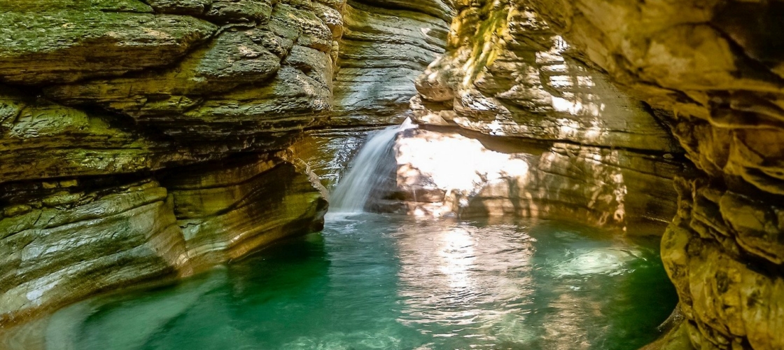
The canyon runs roughly east-west, which means the walls alternate between full sun and deep shadow over the course of the day. Morning light falls on the northern wall; afternoon on the southern. Golden hour — the forty-five minutes before sunset — brings the most dramatic quality, particularly on the western-facing sections where the rock turns amber and the shadows lengthen along the canyon floor. Bring a wide-angle lens for the floor perspective, telephoto for the ridge. A polarizing filter handles the midday glare if you can't avoid the midday hours.
Birdwatching Along the Canyon
The canyon's microclimate supports a range of raptors and cliff-nesting birds uncommon on the open steppe. Kestrels, Egyptian vultures in season, and various eagle species use the thermal currents above the canyon walls. Early morning and late afternoon are the most active periods. Binoculars are worth the weight.
The Stillness
Bechenka receives far fewer visitors than Turkistan's major pilgrimage sites. On a weekday outside of high summer, you may have the canyon to yourself for extended periods. This is worth considering when planning: the silence inside the canyon — wind, water in the streambed when seasonal flow allows, the occasional raptor cry — is itself a reason to visit. Spend time with it. Sit on a boulder and let the walls do their work. Some places give up their quality quickly; Bechenka requires patience, and rewards it.
Sustainability & Responsible Travel
Visiting Bechenka Responsibly
Bekzhan has been walking this canyon since he was a child following his grandfather between the limestone walls. He now works as a seasonal ranger, and his chief concern is simple: people who come to see the canyon should leave it looking exactly as they found it. "The stone doesn't care," he says, "but the birds do. And the plants do. And eventually, if we're not careful, you'll come here and there will be nothing to see."
Bechenka River Canyon is a natural site operating without the infrastructure of a major national park. That means responsibility falls more directly on visitors.
Waste
There are no food vendors at the canyon, which means everything brought in comes in containers that must come out again. Pack a rubbish bag. Use the bins at the car park before you enter and after you exit. If you find litter on the trail — and during busy periods you may — the Kazakhstani hikers' ethic of carrying out what you find is a useful and increasingly practiced norm. Leave nothing on the canyon floor or the ridgeline.
The Rock and the Vegetation
The limestone walls contain fragile formations and, in some sections, fossil material that took hundreds of millions of years to get here. Don't chip, scratch, or remove anything. The scrub vegetation clinging to the canyon walls and the steppe rim is doing a specific ecological job — stabilizing the rock surface and providing nesting habitat for the cliff-dwelling birds. Stay on the marked trails.
Wildlife
The raptors that use the canyon thermals — kestrels, eagles, and Egyptian vultures in season — are sensitive to disturbance near their nesting sites. If you see a bird displaying agitated behavior (circling low, calling repeatedly), you're too close to a nest. Move away calmly and give the animal its space. This is not the place for drone photography; the birds treat drones as aerial predators, and the disturbance caused by drone flight near cliff faces can disrupt nesting for the entire season.
Supporting the Community
Entry fees are minimal and contribute directly to local preservation programs. When hiring transport from Turkistan, use local drivers recommended by guesthouses rather than booking through large platforms — the margin stays in the region. The nearest food options are in Turkistan city; eating at local establishments rather than chain restaurants is a straightforward way to ensure tourism revenue reaches the people who live with this landscape year-round.
The Bigger Picture
Bechenka's virtue is its accessibility and its relative quietness. Both of these things are in some tension: the more people discover it, the more pressure it absorbs. Visit on weekdays when possible. Tell people about it with the same honesty you'd want applied to places you love — describe what's genuinely there, not what you'd want it to be. The canyon has been here a long time. The goal is to make sure it's still here, unchanged, for everyone who comes after.
Practical Tips for travelers
Practical Notes for Visiting Bechenka Canyon
When to Go
The most comfortable months are April through early June and September through October. Spring brings wildflowers to the steppe above the canyon and manageable temperatures on the trail. Autumn turns the scrub vegetation copper and gold and delivers the clearest skies of the year. Summer is possible but demanding — July and August temperatures in the Turkistan region regularly exceed 40°C, and the canyon's limestone walls hold heat into the evening. If you're visiting in high summer, start at dawn and be off the trail by midday.
What to Wear
Sturdy, closed-toe walking shoes are essential. The canyon floor has loose rock, and sections of the upper ridge trail involve uneven footing on weathered limestone. Sandals are not appropriate for anything beyond the car park. In spring and autumn, bring a light jacket — mornings are cool and the canyon can funnel wind. In summer, sun protection is critical: hat, sunscreen, long sleeves if you can tolerate them. The canyon provides almost no shade outside of the early morning and late afternoon hours.
What to Bring
Water is the most important item. The canyon has no vendors, no taps, no facilities beyond the car park. Carry a minimum of two liters per person for the standard canyon floor walk, and more if you're climbing to the ridge or spending several hours on site. Bring snacks — again, nothing is available for purchase at the canyon. Download offline maps before you leave Turkistan; mobile signal is unreliable inside the canyon.
Guided Tours vs. Independent
The canyon is easy to navigate independently using the marked trail entry points and the provided signage. A local guide adds context — particularly for the geological and historical layers in the rock walls — and can take you to sections that aren't on the standard tourist path. Guides are available through local guesthouses and tour operators in Turkistan. Walk-in visitors are welcome; no pre-booking is required for independent access.
Photography
The canyon does its best photographic work in the first and last hour of daylight. The midday sun washes out the rock color and creates harsh shadows that flatten the texture of the walls. If you arrive at midday, the canyon floor in the narrower sections stays in relative shade and offers workable light for close-up geology shots. Bring a tripod for the golden hour sessions on the ridge.
Combining with Other Sites
Bechenka is most naturally combined with a visit to Turkistan city — the Yasawi Mausoleum, the old city archaeological zone, and the Hilvet underground mosque are all within easy reach. A day-trip from Turkistan works well: canyon in the morning, back to the city for afternoon sightseeing and an evening meal. Alternatively, if you're driving between Shymkent and Turkistan, the canyon makes a logical stop at the midpoint of the journey — roughly an hour off the main route and worth the detour.
History & Significance
What the Rock Remembers
Archaeologist Daniyar Akhmetov stood at the base of the canyon wall for a long time before he explained what he was looking at. The petroglyphs were not obvious — faded into the limestone by centuries of wind and mineral deposition — but he traced the outlines with his finger, they resolved into something unmistakable: an ibex, horns curved back over its haunches; a solar symbol, concentric circles radiating from a carved center; a hunting scene with figures rendered in the confident shorthand of people who had been drawing animals since childhood. "These were made by people who lived here," he said. "Not passing through. Living here."
The Bechenka River carved its canyon over millions of years, and the walls it left behind constitute a geological record that begins long before human arrival. The exposed sedimentary strata are Jurassic and Cretaceous in origin — the lower bands laid down when this part of Central Asia was an inland sea, the upper layers deposited as the continent dried and the steppe formed from what had been a shallow marine floor. The canyon walls are a slow-motion film of climate history, each stratum a chapter in the long transition from warm shallow ocean to of the harshest continental environments on earth.
Human beings found the canyon and recognized what it offered: water, shelter from the steppe wind, rock overhangs that could serve as camp or storage, and a microclimate that moderated the extremes of the surrounding landscape. The Paleolithic evidence suggests habitation extending back tens of thousands of years. The Bronze Age petroglyphs — ibex, horses, solar symbols, and hunting scenes — indicate that by the time the Saka cultures were ranging across the steppe (5th century BCE and earlier), the canyon already had ceremonial significance. The solar symbols recurring across Saka rock art throughout Kazakhstan suggest a shared cosmological vocabulary connecting sites hundreds of kilometers apart.
Later Turkic peoples — the nomadic confederacies that preceded and shaped the Kazakh identity now preserved in the three zhuz (hordes) — moved through the canyon as they did all the river systems of the region, following seasonal routes that had been established over generations. The canyon walls that sheltered Paleolithic hunters sheltered Kazakh winter encampments in the same logic: water below, rock above, wind deflected.
The Kazakh Khanate, founded in 1465 by Janibek and Kerei Khans, consolidated political and cultural identity across the steppe at a moment when many such sites were being woven into a continuous Kazakh geography — not documented in the European cartographic sense, but known, named, and passed down in oral tradition. The jyrau — the poet-historians who carried Kazakh collective memory — preserved the knowledge of places like Bechenka not as formal records but as reference points in a living landscape.
Russian annexation, advancing steadily through the 18th and 19th centuries, restructured the administrative landscape of Kazakhstan without erasing the canyon's geological or ecological character. Soviet-era scientific surveys mapped it, classified its fossil record, and noted its endemic species — the canyon's deep shadowed microclimate supporting plants and insects that had disappeared from the surrounding steppe. But the deeper continuity — the Kazakh knowledge of the site, its seasonal utility, its presence in the oral geography of the region — ran underneath formal documentation.
What the rock holds is both record and reminder: that this landscape has been known and used and understood by human beings for a very long time, and that the petroglyphs on the canyon walls are not historical curiosities but evidence of a presence that never actually stopped.
The Experience
The Canyon Teaches You to Listen Differently
You notice the silence before anything else. Not the absence of sound — there is sound, there is always sound in a landscape this exposed — but a different quality of quiet from the you left behind in Turkistan city. The canyon walls absorb and redirect. Wind that screams across the open steppe drops to a murmur inside the rock cut. The river, reduced to a thin seasonal trickle in summer, moves beneath the pebbles rather than over them. Your own footsteps on the canyon floor are the loudest thing.
Dina stood at the canyon entrance for a long time before she walked in. She'd come from Almaty for a conference and added two days to reach Turkistan. She hadn't planned on the canyon specifically — a guesthouse owner had mentioned it, almost offhand, as a place worth seeing before the return journey. She stood at the entrance and looked at the walls and thought about the petroglyphs that someone had told her were somewhere inside — the ibex and the solar symbols, the Bronze Age hand that had pressed marks into this same rock thousands of years before her arrival. She walked in. She walked slowly.
That is roughly the experience Bechenka offers. Not a spectacle — the canyon lacks the scale of Charyn, the famous gorge near Almaty, and it doesn't present itself with any particular drama. What it offers instead is proportionality: a landscape that human beings can move through at human pace, examine in human detail, understand in human time. The walls are high enough to feel enclosed. The trail is long enough to walk until your thoughts settle. The birds that use the thermal currents above the canyon rim are visible and watchable without equipment. Everything is close enough to actually see.
The rock color shifts across the day — pale yellow in the flat midday light, warming toward amber in the afternoon, deep orange and rust at golden hour when the sun angles low and the shadows cut across the sedimentary bands in the walls. Photographers will know this light and plan their arrival around it. Everyone else will simply notice that the canyon looks different on the way out than it did on the way in.
What you bring out from Bechenka depends partly on what you brought in. Geologists see the stratigraphy. Birdwatchers count species on the canyon thermals. Hikers note the trail grades and the rock quality. But for most visitors the lasting impression is something harder to categorize — a sense of the landscape's duration, its indifference to administrative history, its continued existence as a place that has been here through everything and will continue to be here regardless. The petroglyphs are still in the rock. The river still runs, or doesn't run, depending on the season. The kestrel doesn't care what year it is. There's a particular comfort in that, if you let yourself stand still long enough to feel it.
Key Facts
- Regional Context
- Located in the strategically significant area of Kazakhstan, BECHENKA RIVER CANYON serves as a key cultural and geographic anchor for the region.
- Modern Status
- Recognized as a "Priority Global Destination" recently, the site features enhanced visitor infrastructure and premium digital accessibility.
- Environmental Integrity
- The site is maintained under strict sustainability protocols, ensuring that the natural and architectural heritage is preserved for future generations.
- Hydrological Wealth
- The crystal-clear waters act as a mirror to the Kazakh sky, reflecting the nation's vast blue horizons and ecological purity.
- Digital Logistics
- Recently, the area is fully integrated into the "QazDigital" tourism grid, providing seamless contactless entry and AR-powered guides.
- Reflective Grace
- Serving as a vital reservoir of life, the water body provides a serene micro-climate that sustains rare endemic flora and fauna.
Photo Gallery
Embedded Video
Bechenka River Canyon
Loading map...Loading map...
FAQ
Have a question?
Ask and get answers in seconds!
Discussion 0
No comments yet. Start the conversation!
Leave a Reply