Torysh Valley Of Balls
Journey to the edge of the world. Mars on Earth.
Definitive Guide
Torysh: The Valley of Balls (recent Geological Mystery Guide)
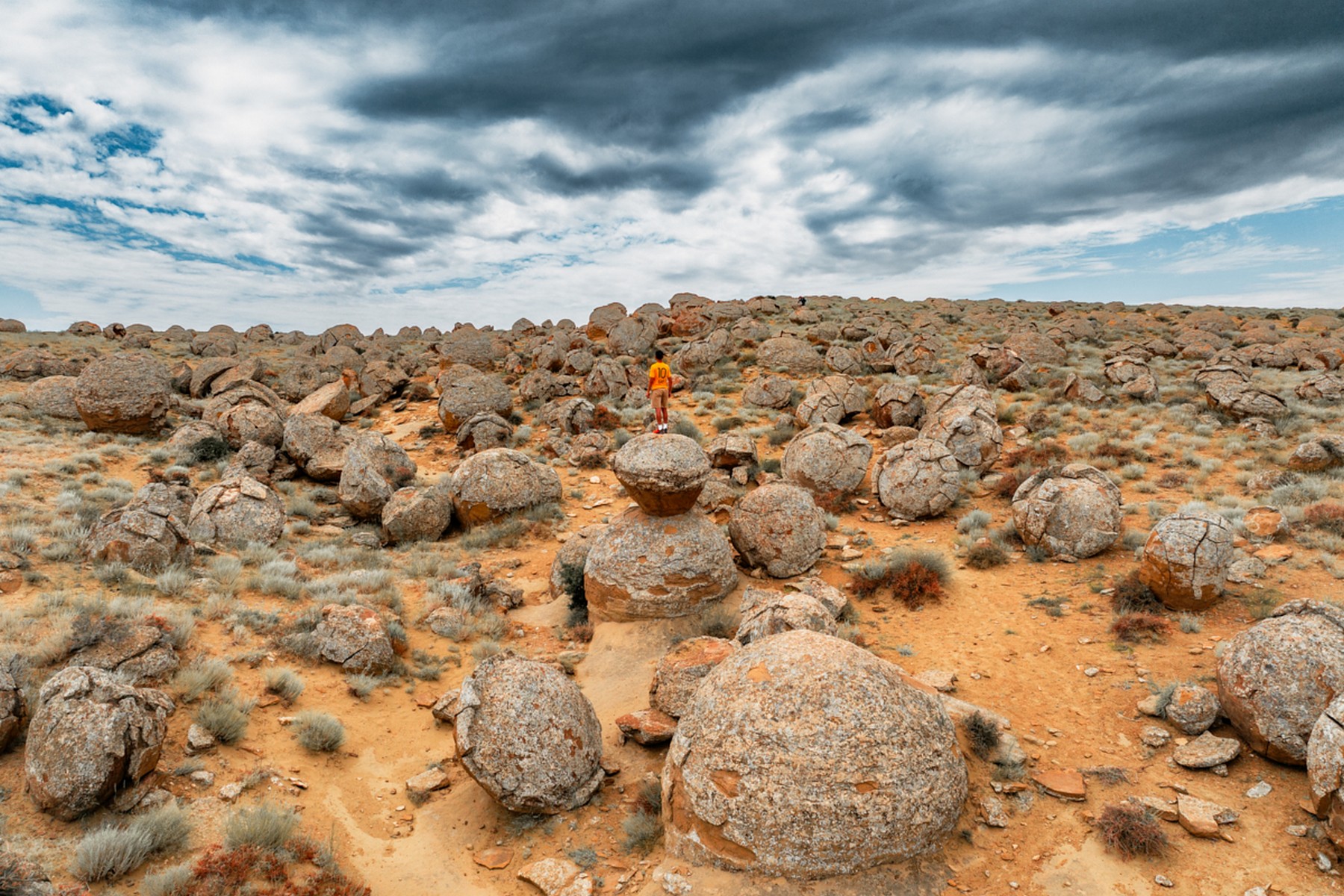
Imagine a vast desert plain scattered with thousands of perfectly spherical stone balls, some as small as marbles, others larger than a car. This is Torysh, of Kazakhstan's most baffling and beautiful natural phenomena.
The Science of the Spheres
For decades, scientists have debated how these boulders—technically known as "Concretions"—were formed. The current consensus is that they grew over millions of years around a central nucleus (like a pearl) at the bottom of the ancient Tethys Ocean. As the ocean receded and the ground lifted, the softer surrounding earth eroded, leaving these hard stone "eggs" behind.
Legends of the Steppe
Local legend tells a more dramatic story: that an invading army was turned to stone by the prayers of a local saint who didn't want the land to be conquered. Walking through the valley at dawn, with the shadows of the "soldiers" lengthening, it’s easy to believe the myth.
recent Logistics & Access
Access: Located about 100km north of Aktau. While the initial road is paved, the "inter-sphere" trails require a vehicle with decent ground clearance.
Interactive Kiosks: Recently, the valley features solar-powered "Geo-Nodes" that explain the concretion process in 3D through transparent OLED displays at key viewpoints.
Permit: No special permit is needed for Torysh, but it is often part of a wider Mangystau circuit.
Essential Experiences
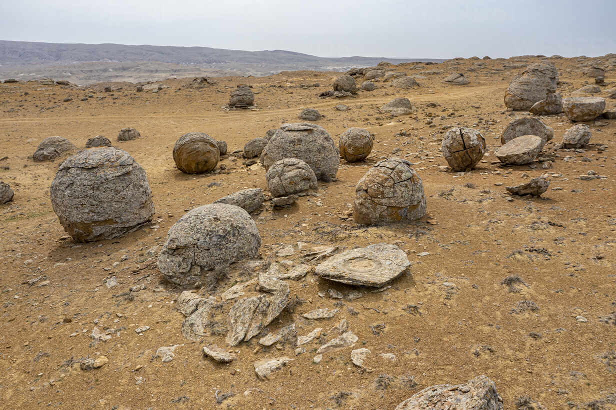
The "Egg Shell" Quest: Find the spheres that have split in half. The internal rings look like tree growth rings and reveal the millions of years of mineral layering.
Night Stargazing: The valley is a Tier-1 Dark Sky zone. Recently, "Star-Seed" overnight camps offer telescopes for guests to view the cosmos surrounded by these prehistoric spheres.
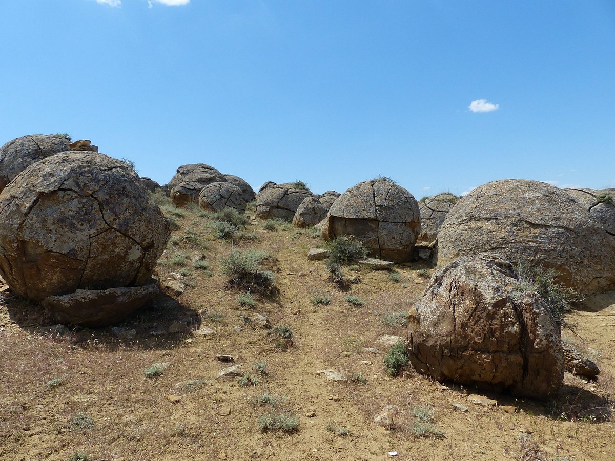
The Giant's Marbles Hike: A 5km trail that takes you through the highest density of the largest spheres.
Travel Tips
Footwear: Wear sturdy boots. The ground between the balls can be uneven and rocky.
Respect the Spheres: Do not attempt to chip or spray-paint the stones. Recently, the valley is under automated environmental monitoring to prevent vandalism.
Photography: Use a "human for scale." The balls are often much larger than they appear in photos.
Essential Profile
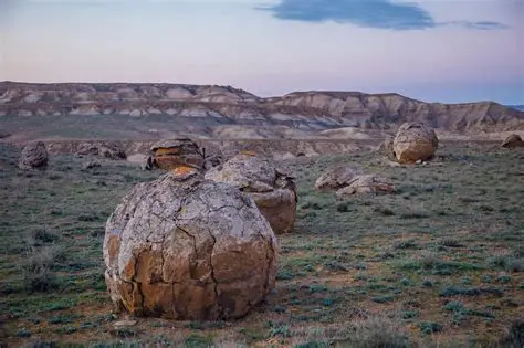
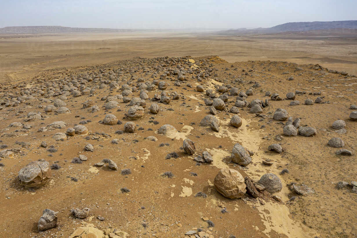
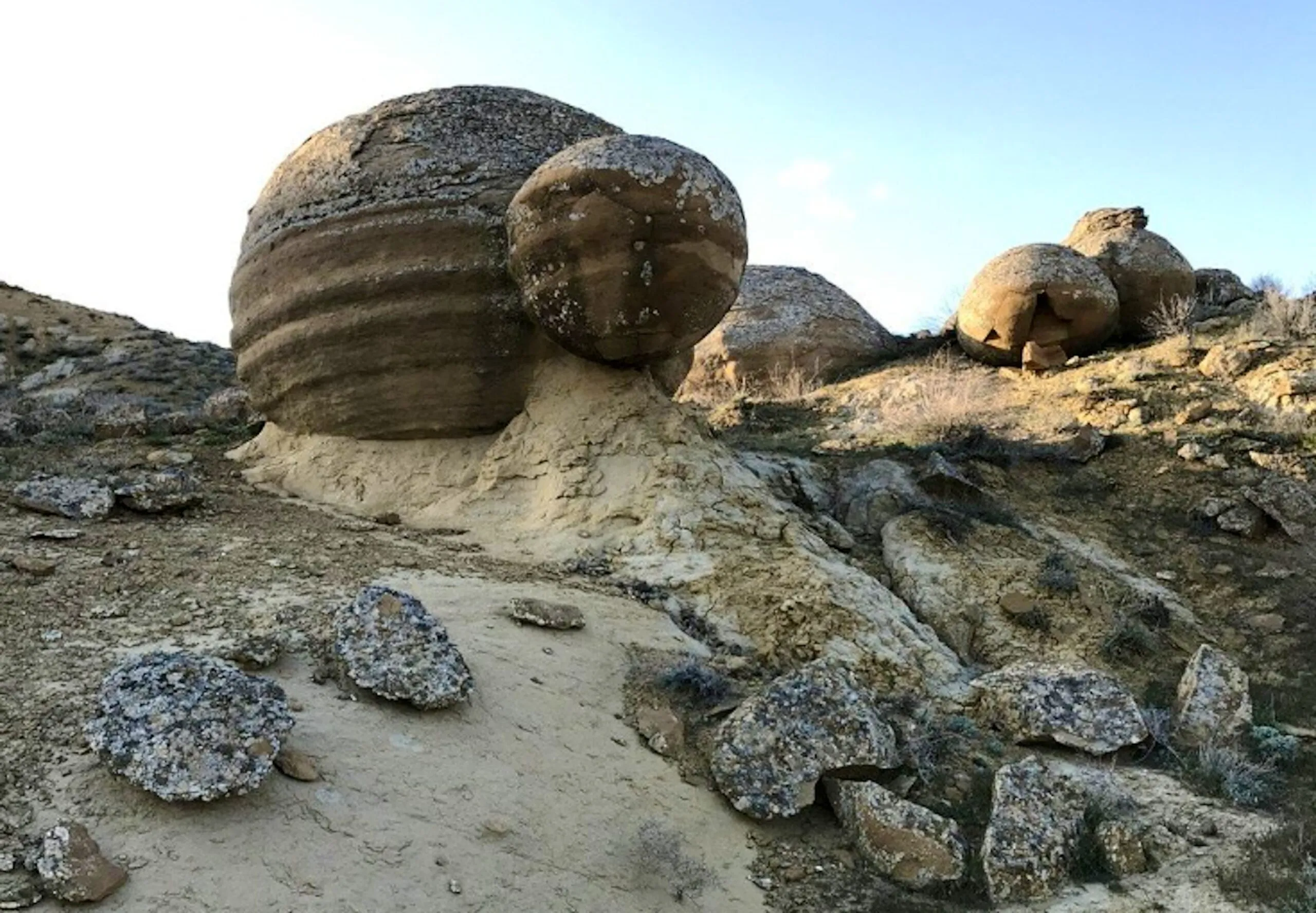
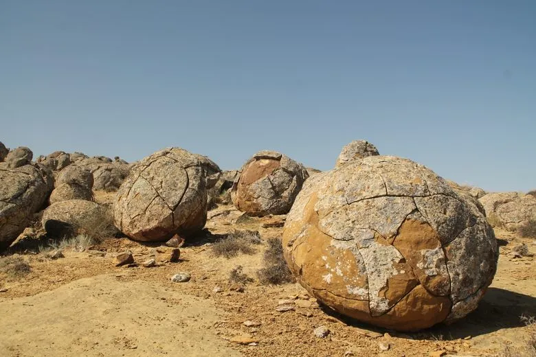
In the Mangystau Region of western Kazakhstan, spread across a depression at the foot of the Karatau plateau about 105 kilometres northeast of Aktau, thousands of stone spheres lie scattered across a chalk landscape as if deposited by something that could not decide between order and randomness. Some are the size of a fist. Some are four metres across and half-buried in the ground. Most are roughly spherical, and none of them look like they belong to any geological process the eye automatically recognises.
Torysh is the name of the valley. The balls are concretions — a geological formation created when minerals in ancient sediment crystallise around a nucleus over millions of years, building outward in concentric layers as a pearl builds in an oyster, until the surrounding softer rock erodes and the harder sphere remains. The Torysh concretions formed in the Cretaceous period, roughly 70 to 180 million years ago, when the area was a shallow sea floor. What is now a dry chalk plateau was the bottom of the Tethys Ocean.
The result, for a visitor arriving today across the stony Mangystau plain, is a landscape that appears edited. The spheres are too uniform, too evenly distributed, too geometrically improbable for the eye to process as natural — and yet natural is precisely what they are, the product of chemistry and time operating on a scale that human activity cannot produce or replicate.
Torysh is of the largest and most impressive concretion fields in the world.
The ‘Wow-Factor’
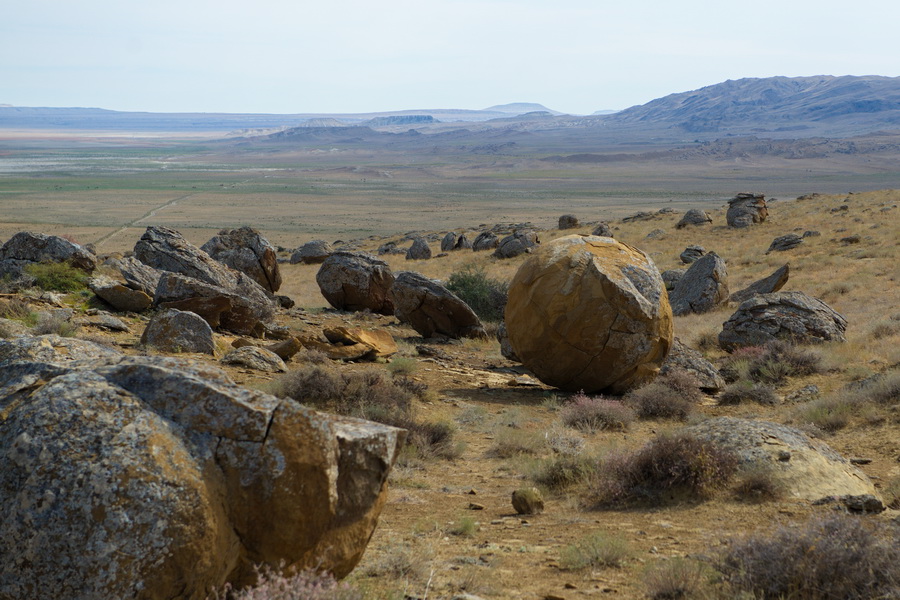
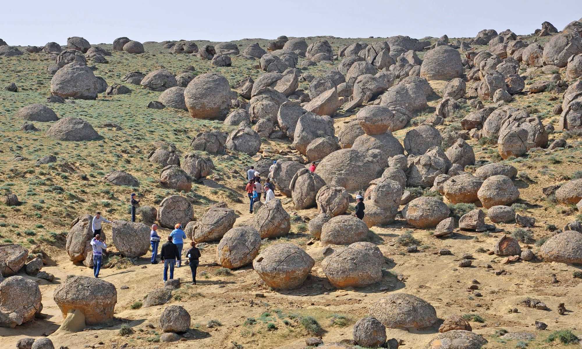
The first view of Torysh stops people mid-stride. Nothing in the approach across the Mangystau plain prepares you for it — the surrounding landscape is sparse and flat and beige, the kind of terrain where the eye has nothing to fix on and the mind starts to drift. Then the valley opens and there they are: hundreds of stone spheres, some small enough to hold in two hands, some large enough to stand on, spread across pale chalk ground in loose clusters and solitary arrangements that the brain initially refuses to parse as geology.
The immediate reaction is that something happened here. The spheres are too numerous and too consistently shaped to feel accidental. A child visiting with her father from Aktau stood at the edge and said, in complete seriousness, that a giant had been playing marbles. She was not wrong as an interpretation of what the eye reports.
Touch is part of the experience. The surfaces of the larger spheres are smooth in the way that river pebbles are smooth, the product of millions of years of exposure to the abrasive steppe wind. Warm in the afternoon sun, they radiate heat back through your palms in a way that makes the geological timescale feel momentarily personal.
The light changes the valley completely across a day. At dawn the spheres cast long shadows on the pale ground and the shapes seem to multiply. At midday everything flattens. At sunset the lower faces go dark while the upper surfaces catch orange and the whole field becomes a composition in geometry and colour that no who photographs it feels they have adequately captured.
Deep History & Culture
The stone spheres at Torysh are concretions — a geological formation with an elegant explanation. During the Cretaceous and early Paleogene periods, between 40 and 180 million years ago, this region was the floor of the Tethys Ocean, a shallow sea that separated the landmasses that would eventually become Europe, Africa, and Asia. Mineral-rich water moving through the seabed sediment began crystallising around small nuclei — fragments of shell, bone, or organic material — building outward in concentric layers over geological time. When the sea retreated and the landscape rose and eroded, the softer surrounding chalk and clay wore away faster than the harder mineral cores, and the spheres were left standing in the plain.
The Mangystau peninsula has been nomadic territory for as long as the steppe has been inhabited. Kazakh oral traditions developed explanations for the spheres long before geology arrived to offer its own account, and those explanations varied by group and generation — stone warriors turned to rock by a protective force, the eggs of enormous creatures, the debris of battles fought by beings too large for ordinary history. The function of such stories was not scientific but navigational in a broader sense: they connected the landscape to human experience and made the incomprehensible terrain of the steppe meaningful.
Russian Imperial cartographers documented the valley in the nineteenth century as they mapped the Mangystau coast prior to the establishment of Aktau (then Fort Aleksandrovsk). Scientific geological study followed in the Soviet period. The site was not protected by formal heritage designation until after independence, when Kazakhstan began systematic identification of its geological and natural monuments.
Practical Logistics ()
Torysh is in western Kazakhstan, in the Mangystau Region. The nearest city and the realistic gateway is Aktau, which has an international airport with flights from Almaty, Astana, Istanbul, and Baku. From Aktau, the valley sits roughly 105 kilometres to the northeast.
The road to the village of Tauchik (about 95 kilometres) is paved and in reasonable condition. The final ten kilometres from the village to the valley is unpaved — dry, stony tracks across open steppe that require a vehicle with proper clearance. A standard sedan risks damage from the sharp limestone surface. A 4WD with high clearance is the practical minimum.
Options for getting there are: hire a driver-guide in Aktau who knows the route, which costs around 50,000 to 70,000 tenge per day and includes fuel and the navigation knowledge the track requires; rent a 4WD independently, which costs 35,000 to 50,000 tenge per day but requires offline maps or GPS coordinates downloaded before you lose mobile signal; or join an organised Mangystau tour that packages Torysh with other sites in the region.
The area has no services — no fuel, no water, no food, no accommodation — beyond what you bring or what exists in Tauchik village. Stock up in Aktau completely. Carry a minimum of three litres of water per person for a day visit, more in summer when temperatures on the exposed steppe exceed 40 degrees. A basic puncture repair kit is worth having given the road surface.
The best seasons are April through June and September through October. Summer heat on the chalk plain is significant.
Must-Do Activities & Experiences
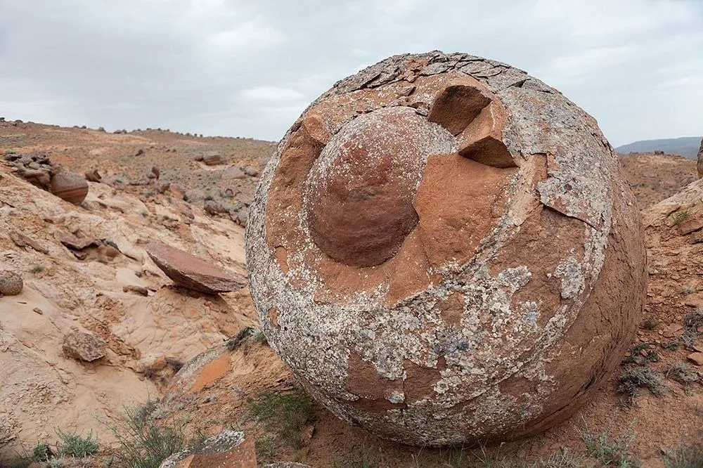
Walking through Torysh slowly is the activity. There is no formal trail, no entrance procedure beyond the site fee, and no obligation to move in any particular direction. The best approach is to spend two to three hours simply moving through the field, crouching next to the smaller spheres to compare them to the large, examining the fractures and cleavage lines where some have split and the interior concentric rings are visible — the evidence of how the sphere was built, layer by layer, over geological time.
The interior of a fractured concretion is of the more extraordinary things you can encounter at ground level on the Mangystau plain. The rings are distinct and varied, sometimes different colours, sometimes different textures, a record of the changes in mineralogy that occurred across millions of years of crystallisation. It is a geological cross-section of deep time available to anyone willing to crouch down and look.
Overnight camping among the spheres is transformative in a way that day visits are not. The Mangystau steppe has minimal light pollution, and the night sky over Torysh — on a clear moonless night — delivers the Milky Way at full intensity, arching over a landscape populated by spherical silhouettes. The absence of artificial sound, in the deep night, is complete. This is genuinely dark country, genuinely quiet, and the experience of it persists after you leave.
The surrounding Mangystau plateau has additional sites worth visiting in combination: the Shakpak Ata underground mosque, the Bozzhira canyon, and the Ustyurt Plateau edge cliffs are all within a multi-day driving loop.
Local Flavors & Amenities
The Torysh area offers nothing in the way of restaurants or cafes at the site itself. The nearest settlement with food is Tauchik village, where small local eateries and guesthouses serve the straightforward cooking of the Mangystau steppe.
Camel meat features prominently in the Mangystau kitchen in a way it does not in the mountain regions around Almaty. Besbarmak made with camel rather than lamb — boiled, shredded, laid over flat noodles with broth poured alongside — has a different texture and a slightly stronger flavour, and it is the appropriate thing to eat in a landscape that sustains camels and has fed people on their products for centuries. Shubat, fermented camel milk, is the regional drink: sour, fizzy, and refreshing in a way that dairy products from other animals are not. It is an acquired taste for some and instantly appreciated by others; it is also, under the desert sun, genuinely effective at cooling the body.
Aktau, the regional capital, has a full range of accommodation and food options at every price point. Staying in Aktau and driving to Torysh as a day trip is the most logistically comfortable option. For those who want to spend the night closer to the site, yurt camps have been established in the surrounding steppe and provide a camping experience with the convenience of pre-erected shelter. Basic food is typically included.
Bring lunch, snacks, and all your water from Aktau. The drive out and back is long enough that arriving hungry is a regrettable choice.
Essential Insider Tips
Visit in spring or autumn. April through June and September through October give manageable temperatures on the exposed steppe. July and August are not impossible but the chalk plain in full summer heat, with no shade anywhere between the vehicle and the horizon, is genuinely punishing. The spheres will still be there in May.
The temperature in Mangystau swings dramatically between night and day — sometimes 20 degrees across a single cycle. A pre-dawn visit, which produces the best photography light and the coolest air, requires layers that you will want to remove by midmorning. Pack both.
Do not rely on phone GPS alone. The Mangystau plateau has variable signal coverage and the tracks through the steppe are not consistently marked on standard mapping apps. Download offline maps or GPS coordinates before you leave Aktau, carry them in a separate device or a printed backup, and tell someone your planned return time. This is not catastrophising — it is basic practice for remote steppe travel where the nearest help is an hour's drive.
Do not remove stones. This applies to the spheres themselves and to the geological material surrounding them. Removing specimens destroys the context that makes the site scientifically legible and is illegal under Kazakhstani heritage law.
The Mangystau wind is not decorative. It blows consistently and with force, particularly on the open plateau. Secure any loose gear, protect your camera from dust, and expect your ears to be cold even on warm days when the air in Aktau feels entirely benign.
Sustainability & Responsibility
Torysh is a geological site of international significance with minimal management infrastructure. The combination means that visitor impact matters disproportionately here compared to more heavily managed destinations. The site has no permanent ranger presence throughout the day, no fencing, and limited signage. Responsible behaviour is therefore self-directed rather than enforced.
The most important rule is non-disturbance of the geological material. The concretions themselves are physically robust — you cannot damage a four-metre stone sphere by standing near it — but the surrounding chalk substrate contains additional geological information in the form of smaller concretion fragments, fossil material, and stratigraphic layers that are irreplaceable disturbed. Walking off the natural pathways that have formed between the spheres spreads disturbance across a wider area and erodes material that scientists are still studying.
The remote steppe around Torysh is not waste ground. It supports steppe wildlife — birds of prey, reptiles, small mammals — whose presence depends on the undisturbed chalk and clay habitat that the site occupies. The Mangystau Region has several endemic species found nowhere else. Minimising vehicle movement off established tracks, avoiding disturbance to nesting sites, and controlling noise in the early morning when wildlife is most active are all meaningful practices.
Supporting Tauchik's local economy directly — food from local kitchens, accommodation at local guesthouses, crafts from local producers — keeps a larger proportion of the tourism revenue in the community that has lived adjacent to this landscape for generations and that bears the costs of any environmental degradation it suffers.
History & Geology
The geology of Torysh connects to of the more dramatic chapters in Earth's physical history. The Mangystau Region sits on the edge of the ancient Tethys Ocean basin — a shallow tropical sea that separated Europe and Asia and stretched from what is now the Atlantic to the western Pacific. During the Cretaceous and early Paleogene periods, this area was submerged under that sea, accumulating thick sequences of carbonate sediments, fossil material, and mineral-rich water over tens of millions of years.
Concretion formation is a sedimentary process that occurs when groundwater containing dissolved minerals moves through porous sediment and begins to precipitate around a nucleus — a fragment of shell, a bone, a mineral grain, anything that creates the right chemical conditions. The precipitation builds outward concentrically, layer by layer, at rates measured in geological time. The result is a harder mineralised mass within a softer matrix. When the sea retreated and the Mangystau plateau rose and began eroding, the softer surrounding material — chalk, clay, soft limestone — wore away preferentially, leaving the harder concretions standing.
The Torysh concretions are composed primarily of calcite and dolomite and are significantly harder than the chalk plateau that surrounds them. Their spherical shape results from the isotropic nature of the crystallisation process: precipitation moves equally in all directions from a central nucleus, producing a sphere rather than an irregular mass.
Similar concretion fields exist in New Zealand, Canada, and the United States, but the scale of Torysh — thousands of spheres across a wide valley, ranging from a few centimetres to over four metres in diameter — makes it exceptional among sites of this type globally.
The Experience
By mid-afternoon at Torysh, after the initial shock of the landscape has settled, a different quality of attention takes over. You stop moving quite so purposefully and start sitting on or near the spheres, watching the light on the chalk ground change, noticing the differences between individual stones that initially seemed identical.
Some have fracture lines running across their surfaces where the internal stress of the crystallisation process eventually exceeded the structural tolerance. These fractured specimens show their interior rings — concentric layers of varying colour and density, each representing a different period in the concretion's formation. Standing next to a split sphere and seeing its cross-section is like reading a geological log of the ancient sea floor in a form you can hold your hand against.
The smallest concretions, fist-sized and palm-sized, are scattered between the large and are easy to overlook. They are the same process in miniature and in many ways the most photogenic objects at the site — a single small sphere on pale ground, precisely round, with the steppe wind-marks in the chalk surrounding it.
The wind at Torysh is constant and directional. It moves from the Caspian direction, generally from the west, and the pale dust it carries settles in fine layers on the lee side of each sphere. Over time, these small drifts build up and shift and rebuild, a record of the wind's direction in miniature dunes that reset with each storm.
At dusk, with the light flat and orange and the horizon absolutely level except for the scattered spheres, the steppe looks like it has always looked: indifferent, geometrically precise, and entirely its own.
Key Facts
- Geological Mystery
- The valley contains thousands of perfectly spherical stone nodules, some reaching several meters in diameter, whose origin remains a scientific debate.
- 120 Million Year History
- These 'stone balls' formed during the Cretaceous period at the bottom of the ancient Tethys Ocean, fossilizing mineral cores over eons.
- UFO Legends
- The surreal landscape has given rise to numerous local legends and 'alien' theories, making it a hotspot for mystery seekers.
- Vast Scale
- The 'balls' are spread across a massive valley floor, looking from above like marbles scattered by a giant on the desert surface.
- Photographic Surrealism
- The interplay of shadows on the spheres at sunset creates a visual experience that is unlike any other landscape on the planet.
- Scientific Significance
- The site is an important geological preserve, helping scientists understand the formation of nodules and the history of ancient oceans.
Photo Gallery
Embedded Video
Torysh Valley Of Balls
Loading map...Loading map...
FAQ
Have a question?
Ask and get answers in seconds!
Discussion 0
No comments yet. Start the conversation!
Leave a Reply